Understanding GPS precision in IASO: how to ensure high-quality spatial data

April 2, 2026

The success of public health interventions often depends on a single question: exactly where was this data collected? Whether you are mapping health facilities or tracking a vaccination campaign, GPS precision is the backbone of your spatial analysis. At Bluesquare, we designed IASO to handle the realities of the field, where hardware limitations and environmental factors meet the need for high-quality georeferencing.

Factors influencing GPS accuracy on the ground

Before looking at the software, it is essential to understand that GPS performance is primarily a hardware and environmental matter. The accuracy of a coordinate is determined by the quality of the device’s GPS sensor and its ability to communicate with satellite constellations.

The impact of environment and hardware

Weather conditions, such as heavy cloud cover, and physical obstacles like dense forest canopies or high-rise buildings, can deflect or weaken signals. However, the device itself is often the biggest variable. A high-end smartphone will typically achieve a faster and more stable satellite fix than a low-cost tablet. In most standard field conditions, our data shows that users can expect an average accuracy range between 5 and 15 meters.

Optimizing georeferencing through IASO and ODK

While we cannot control the clouds, we can control how the software reacts to them. By leveraging the power of ODK forms within the IASO ecosystem, organizations can implement strict protocols to safeguard spatial data quality.

Enforcing accuracy thresholds in data entry 

One of the most effective features for ensuring data integrity is the ability to set a mandatory accuracy threshold. Within a form, you can configure the system to reject any GPS coordinate that does not meet a specific requirement—for example, requiring a precision of less than 10 meters. The data collector is then prompted to wait a few seconds longer for a better signal, ensuring that no “fuzzy” data enters your database.


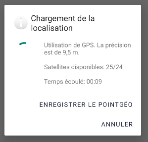
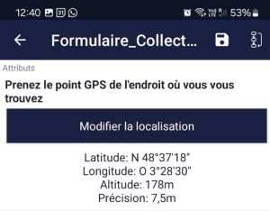
Illustration of GPS reception in IASO

Reliability in numbers 

When these best practices are applied, the results are highly consistent. In 95% of cases involving GPS-enabled questions in our recent campaigns, we achieved a GPS precision of less than 10 meters. This level of reliability allows program managers to trust their maps and make informed decisions based on pinpoint-accurate information.

Evidence from the field: high-precision georeferencing in action

The theoretical potential of GPS precision is best demonstrated through large-scale operations. In Western and Central Africa, IASO has been the cornerstone of several campaigns where spatial accuracy was not just a bonus, but a requirement for success.

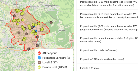
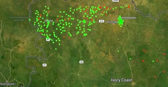
Ensuring coverage in Côte d’Ivoire 

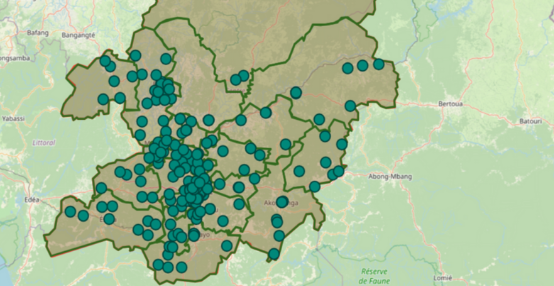
During the 2025 Seasonal Malaria Chemoprevention (SMC) campaign in Côte d’Ivoire, the National Malaria Control Program (PNLP) used IASO to track interventions across four cycles. By implementing data entry protocols that required precise coordinates, the teams ensured that every household reached was accurately mapped. This allowed for real-time monitoring of coverage gaps, transforming raw GPS coordinates into an actionable management tool.

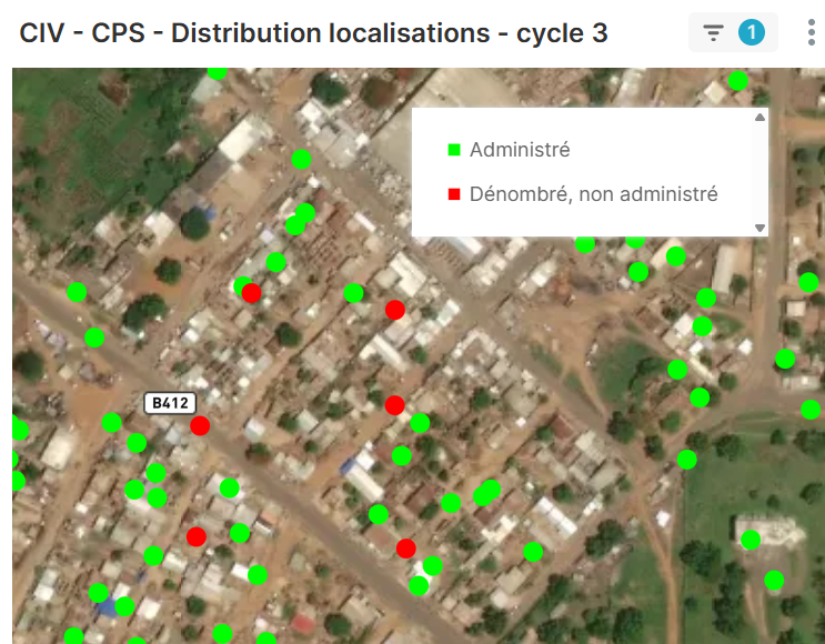
Reaching households on IASO

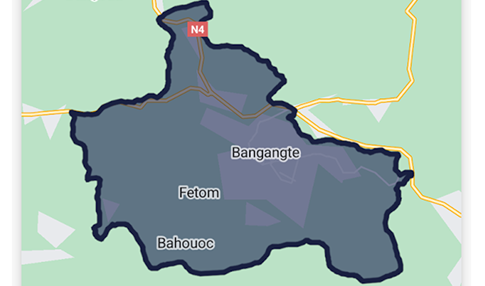
Reliability benchmarks in Cameroon 

The results from our deployments in Cameroon further validate the robustness of the system. In 95% of cases where GPS data was collected via IASO, the accuracy recorded was under 10 meters. Despite the challenges of varied terrain and fluctuating satellite availability, the combination of capable hardware and IASO’s validation logic consistently delivered high-quality spatial data.

Balancing technology and methodology

Achieving high GPS precision is a collaborative effort between the device, the environment, and the software. While atmospheric conditions and hardware sensors set the physical limits, IASO provides the necessary digital guardrails to ensure that only the most accurate data is recorded. For public health leaders, this means moving beyond simple “data collection” toward true, reliable georeferencing that stands up to the most rigorous analysis.

Trusted by

IASO has become a trusted name for health data management with implementations in 15 countries and two large-scale multi-country projects, in support to the Global Polio Eradication Initiative and UN nutrition programs.
  • World Health Organization
  • The World Bank
    The World Bank
  • USAID
  • PMI logo
    U.S. President's Malaria Initiative
  • Unicef
  • GAVI logo
    Gavi
  • Gates Foundation
  • Clinton Health Access Initiative
  • Cordaid
  • Lifenet logo
    Lifenet international
  • Abt Associates
    Abt Associates
  • Centre for Humanitarian Dialogue
    Centre for Humanitarian Dialogue
  • SANRU - Soins de Santé primaires en milieu Rural (DRC)
    SANRU - Soins de Santé primaires en milieu Rural (DRC)
  • Cameroon Expanded Programme on Immunization
    Cameroon Expanded Programme On Immunisation
  • Ministry of Health Burkina Faso
    Burkina Faso Ministry of Health
  • Cote d'Ivoire Malaria National Programme
    Cote d'Ivoire Malaria National Programme
  • Democratic Republic of Congo Ministry of Health
    Democratic Republic of Congo Ministry of Health
  • Niger Ministry of Health
    Niger Ministry of Health

Latest about IASO

IASO enables for nutrition stock management.

IASO for Nutrition was designed to enable governments and partners to manage beneficiary tracking, program monitoring, and reporting within a unified digital environment. This ecosystem has been expanded with a fully integrated Stock Management module, strengthening control and visibility across the entire nutrition supply chain.

Updating the health map is a cornerstone of healthcare planning. In Benin, integrating the georegistry through the IASO platform has helped transform often fragmented data into a single, dynamic source of truth for the national system.

Fragmentation creates a heavy burden on health systems and field workers. By aligning with the WHO toolkit for campaign digitalization, Bluesquare’s IASO platform enables the transition to integrated campaigns, allowing multiple health interventions to be managed through a single, georeferenced digital infrastructure

In Côte d’Ivoire, the 2025 Seasonal Malaria Chemoprevention (SMC) campaign illustrates how robust data products and end-to-end technical support can strengthen health service delivery for the population. Discover why IASO is a data collection and processing solution tailored to the operational challenges of the field.

Farm mapping in Burkina Faso

IASO provides a comprehensive and flexible solution for agricultural data management. Its geospatially-enabled architecture, mobile data collection, traceability features and integration capabilities make it well-suited to meet the evolving requirements of agricultural markets and regulatory frameworks.

Along with its form-based approach to data collection, IASO has an advanced geospatial data management allowing for decentralization of responsibilities and task planning according to geography, as well as powerful map-based visualizations.

In fields like public health, access to comprehensive geographic data is crucial for designing targeted and effective interventions. That’s exactly the need Bluesquare set out to meet with IASO, its geographic data management platform now rolled out in 14 countries. Let’s dive into the 5 essential features that make IASO a go-to georegistry solution.

Ready to get started

Get started

Request demo account

Fill out the information below to create a IASO demo account. You will receive an email with temporary credentials.